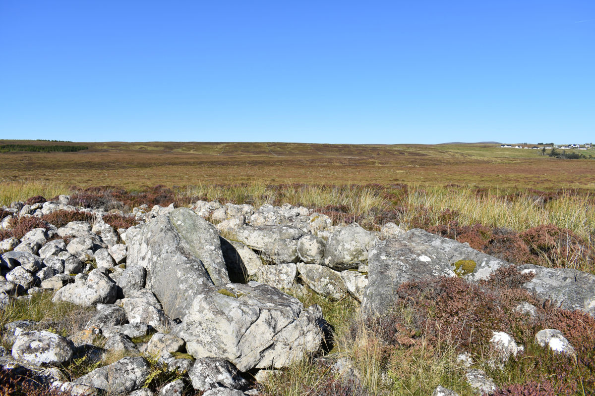
Sgrùdadh arc-eòlais Archaelogical survey

Chambered cairn at Upper Coll chambered cairn near Upper Coll

As part of Comhairle nan Eilean’s Crown Estate funding awards, Comann Eachdraidh Sgìre a’ Bhac (Back Historical Society) received £5,000 to carry out an archaeological survey of Back. The survey had be completed before March 2022, and the results have been written up in a book, available to buy from our online shop.

Arch Walks CEBac logo

Cuairtean Àrsaidh

Introduction

As part of the archaeological survey of Sgìre a’ Bhac 9 group walks were undertaken by retained CEBac archaeologist Ian Mchardy and local volunteers. Details of these routes, and reports on each of them, are given below.

The guiding principle in selecting them has been what might be called “waterways and high places” -- i.e. the focus was on rivers, coasts, streams and prominences. An effort was also made to visit the known (or suspected) sites documented on canmore.org.uk.

Please note

It should be noted that walking on the Lewis moor is challenging. Terrain is very often marshy, making even short walks taxing. Fissures and hags are common, and smaller pits and sinkholes can be invisible until stepped in. Some coastal regions are marked by steep cliffs with sheer drops. For all these reasons, it is essential that volunteers have a basic level of fitness and are comfortable with the demands each walk may make of them. The nature of this study means that most routes are not chosen for ease of walking - they will take place off road and away from recognised paths and by-ways.

An attempt is made to outline the potential dangers of each walk, but the comann cannot take responsibility for anyone who follows these routes and gets into difficulty!

Routes

  • Map routes given should be considered approximations, and may be deviated from where the terrain makes this necessary.
  • For each walk, known (or suspected) points of interest have been extracted from the Canmore database.
  • Each walk is accompanied by a brief report (PDF) by Ian Mchardy on archaeological points of interest.
  • An informal report for each walk was written by one of the volunteers as well.
  • A selection of pictures for each route may be viewed as a popup gallery.

(Click on each walk title to expand it.)

Walk 1 - Tràigh Sheilibhig and Dùn Beinn Earba

Length: 6km (approx)

Ascent: 161m

Time: 5 hours (approx)

Hazards: steep cliffs, marshy moorland, slippery rocks

CANMORE ID

SITE NUMBER

SITE NAME

SITE TYPE

SITE EASTING

SITE NORTHING

NGR

URL

335457

NB54SW 17

Coll

Field System (Modern)

150162

941912

NB 50162 41912

http://canmore.org.uk/site/335457

4413

NB54SW 3

Lewis, Gress

Midden (Period Unassigned), Unidentified Pottery

150400

941800

NB 504 418

http://canmore.org.uk/site/4413

335456

NB54SW 16

Coll

Field System (Post Medieval)

150577

941834

NB 50577 41834

http://canmore.org.uk/site/335456

335455

NB54SW 15

Druim Mor

Dyke (Period Unassigned)

151487

941968

NB 51487 41968

http://canmore.org.uk/site/335455

128087

NB54SW 5

Lewis, Sheilavaig Mor

Farmstead (Period Unassigned)

151220

943220

NB 5122 4322

http://canmore.org.uk/site/128087

335452

NB54SW 12

Tolsta

Curvilinear Enclosure (Period Unassigned)

151276

943206

NB 51276 43206

http://canmore.org.uk/site/335452

335453

NB54SW 13

Tolsta

Rectilinear Enclosure (Period Unassigned)

151294

943198

NB 51294 43198

http://canmore.org.uk/site/335453

335451

NB54SW 11

Tolsta

Curvilinear Enclosure (Period Unassigned)

151264

943255

NB 51264 43255

http://canmore.org.uk/site/335451

335454

NB54SW 14

Sheilavig Mor

Stone Row (Neolithic)-(Bronze Age)

151331

943240

NB 51331 43240

http://canmore.org.uk/site/335454

335450

NB54SW 10

Tolsta

Curvilinear Enclosure (Period Unassigned)

151382

943245

NB 51382 43245

http://canmore.org.uk/site/335450

335449

NB54SW 9

Sheilavig Mor

Cultivation Remains (Period Unassigned)

151484

943313

NB 51484 43313

http://canmore.org.uk/site/335449

4411

NB54SW 1

Lewis, Earabhic, Dun Beinn Earba

Dun (Period Unassigned)(Possible)

151800

943800

NB 518 438

http://canmore.org.uk/site/4411

4412

NB54SW 2

Lewis, Glen Tolsta

Trap

152000

944000

NB 52 44

http://canmore.org.uk/site/4412

128086

NB54SW 41

Lewis, Glen Tolsta, Bun A' Ghlinne

Mill(S) (Period Unassigned)(Possible)

152110

944540

NB 5211 4454

http://canmore.org.uk/site/128086

128085

NB54SW 40

Lewis, Glen Tolsta, Bun A' Ghlinne

Head Dyke(S) (Post Medieval), Mill(S) (Period Unassigned)(Possible), Township (Period Unassigned)

152200

944500

NB 5220 4450

http://canmore.org.uk/site/128085

Walk 2 - An Gàrradh Dubh

Length: 9.5km (approx)

Ascent: 105m

Time: 4½ hours (approx)

Hazards: marshy moorland, hidden streams

This walk attempts to trace the turf dyke known as the Gàrradh Dubh (Black Wall). It also visits Loch Corsabhat, which has a sluice gate (according to the OS map).

CANMORE ID

SITE NUMBER

SITE NAME

SITE TYPE

SITE EASTING

SITE NORTHING

NGR

URL

136479

NB44SE 43

Buaile Ghlas, Griais, Lewis

Head Dyke (Post Medieval), Township (Period Unassigned)

149220

942650

NB 4922 4265

http://canmore.org.uk/site/136479

136476

NB44SE 51

Loch Beinn Iobheir, Lewis

Shieling Hut (Post Medieval)(Possible)

149420

943630

NB 4942 4363

http://canmore.org.uk/site/136476

4342

NB44SE 8

Dun Beinn Ivor, Loch Beinn Iobhair, Lewis

Dun (Period Unassigned)(Possible)

149500

943600

NB 495 436

http://canmore.org.uk/site/4342

136477

NB44SE 50

Loch Beinn Iobheir, Lewis

Shieling Hut (Post Medieval)(Possible)

149650

943550

NB 4965 4355

http://canmore.org.uk/site/136477

335878

NB54SW 18

Gress Peats

Findspot (Post Medieval)

150250

943749

NB 50250 43749

http://canmore.org.uk/site/335878

136471

NB44SE 37

Lewis, Druim Riabhach

Shieling Hut(S) (Post Medieval)(Possible)

149230

944360

NB 4923 4436

http://canmore.org.uk/site/136471

136468

NB44NE 32

Lewis, Loch Domhain

Shieling Hut (Post Medieval)(Possible)

149340

945160

NB 4934 4516

http://canmore.org.uk/site/136468

136545

NB44NE 17

Lewis, Feadan A' Loch Sgeireich Mhoir

Shieling Hut (Post Medieval)(Possible)

149300

945280

NB 4930 4528

http://canmore.org.uk/site/136545

136543

NB44NE 26

Lewis, Airigh Loch Nan Geadh

Shieling Hut(S) (Post Medieval)(Possible)

148590

946220

NB 4859 4622

http://canmore.org.uk/site/136543

136472

NB44SE 38

Lewis, Feadan Na H-inghinn

Shieling Hut (Post Medieval)(Possible)

148670

944900

NB 4867 4490

http://canmore.org.uk/site/136472

Walk 3 - Gàrradh a’ Mheadhain-oidhche/Càrn a’ Mharc

Length: 6km (approx)

Ascent: 85m

Time: 2 hours (approx)

Hazards: marshy moorland with hidden sinkholes, steep hillside descent

This walk takes in the village head dykes above the meeting hall before following the enigmatic Garadh Druim Braigh an Uillt (also known as the midnight wall) out into the moor. It then loops round Loch a’ Chàirn before approaching Carn a’ Mharc from the moor side. The return follows the 70m contour line, keeping to the south of the summit of Beinn Chailein, striking the south peat road and following it back into the village.

Canmore has little to look out for on this route other than the Càrn itself. The other two entries are for a dyke (marked at the start of the walk) and this entry:

Classification : Field System (Period Unassigned)(Possible), Wall (Prehistoric)

Canmore Id : 334770

canmore.org.uk/site/334770

NGR: NB 47491 42897

Easting/Northing: 147491, 942897

Latitude/Longitude: 58° 18′ 07″ N 6° 18′ 42″ W

Walk 4 - Staran nam Boireannaich to Sìthean Àirigh Mhurchaidh

Length: 7km (approx)

Ascent: 77m

Time: 4½ hours (approx)

Hazards: marshy moorland, river bank fissured with small streams, at times river goes through gorges with steep slippery sides

This walk follows the Gress river out along the old track known as the women’s road (the traditional route taken out to the Back sheilings). The destination (Sìthean Àirigh Mhurchaidh) was where most of the shielings were concentrated. The walk route assumes walking out one bank and back on the other, although an alternative route would be to follow the peat road back.

CANMORE ID

SITE NUMBER

SITE NAME

SITE TYPE

SITE EASTING

SITE NORTHING

NGR

URL

136481

NB44SE 45

Griais, Lewis

Head Dyke (Post Medieval), Township (Period Unassigned)

148400

942000

NB 4840 4200

http://canmore.org.uk/site/136481

136489

NB44SE 49

Abhainn Ghriais, Lewis

Enclosure (Period Unassigned), Field System (Period Unassigned)

148050

941900

NB 4805 4190

http://canmore.org.uk/site/136489

136473

NB44SE 39

Linne Sgorach, Lewis

Shieling Hut (Post Medieval)(Possible)

147810

942190

NB 4781 4219

http://canmore.org.uk/site/136473

136478

NB44SE 42

Bottom Long Pool, Lewis

Building (Period Unassigned)

147600

942510

NB 4760 4251

http://canmore.org.uk/site/136478

136437

NB44SE 35

Sgarrasgir, Lewis

Farmstead (Period Unassigned)

146960

943390

NB 4696 4339

http://canmore.org.uk/site/136437

136423

NB44SE 28

Clach Na Sgarrasgir, Lewis

Shieling Hut (Post Medieval)(Possible)

146860

943400

NB 4686 4340

http://canmore.org.uk/site/136423

136422

Cnoc nan Clach, Lewis

Shieling Hut (Post Medieval)(Possible)

146693

943865

NB 46693 43865

https://canmore.org.uk/site/136422

136459

Cnoc nan Clach, Lewis

Shieling Hut (Post Medieval)(Possible)

146548

943985

NB 46548 43985

https://canmore.org.uk/site/136459

136450

Sìthean Àirigh Mhurchaidh

Shieling Hut (Post Medieval)(Possible)

146439

944161

NB 46439 44161

https://canmore.org.uk/site/136450

Walk 5 - Muirneag

Length: 14½km (approx)

Ascent: 208m

Time: 7 hours (approx)

Hazards: marshy moorland, river bank fissured with small streams

This route follows the upper section of the Gress River, starting at Sìthean Àirigh Mhurchaidh, past the old dam, then branching off at Allt a Deas Muirneag to climb Muirneag itself.

The river banks are easier to walk than the direct route across the blanket bog, but occasional fissures and tributaries make the going slow and difficult at times.

The canmore records for this route all refer to possible sheiling sites.

CANMORE ID

SITE NUMBER

SITE NAME

SITE TYPE

SITE EASTING

SITE NORTHING

NGR

URL

136460

NB44SE 17

Lewis, Sidhean Airiagh Mhurchadh

Shieling Hut(S) (Post Medieval)(Possible)

146400

944370

NB 4640 4437

http://canmore.org.uk/site/136460

136491

NB44SE 25

Lewis, Allt Leig An Fhilidh

Shieling Hut (Post Medieval)(Possible)

146370

944560

NB 4637 4456

http://canmore.org.uk/site/136491

136490

NB44SE 24

Lewis, Allt Leig An Fhilidh

Shieling Hut (Post Medieval)(Possible)

146390

944700

NB 4639 4470

http://canmore.org.uk/site/136490

136463

NB44SE 36

Lewis, Allt Leig An Fhilidh

Shieling Hut (Post Medieval)(Possible)

146420

944840

NB 4642 4484

http://canmore.org.uk/site/136463

136497

NB44NE 27

Lewis, Allt Leig An Fhilidh

Shieling Hut (Post Medieval)(Possible)

146370

945040

NB 4637 4504

http://canmore.org.uk/site/136497

136508

NB44NE 28

Lewis, Allt Leig An Fhilidh

Shieling Hut (Post Medieval)(Possible)

146560

945240

NB 4656 4524

http://canmore.org.uk/site/136508

136467

NB44SE 20

Lewis, Airigh Eagisgra

Shieling Hut(S) (Post Medieval)(Possible)

146110

944440

NB 4611 4444

http://canmore.org.uk/site/136467

136486

NB44SE 22

Lewis, Airigh Eagisgra

Shieling Hut(S) (Post Medieval)(Possible)

145930

944850

NB 4593 4485

http://canmore.org.uk/site/136486

136487

NB44SE 23

Lewis, Airigh Eagisgra

Shieling Hut (Post Medieval)(Possible)

145930

944950

NB 4593 4495

http://canmore.org.uk/site/136487

136517

NB44NE 31

Lewis, Gress River

Shieling Hut(S) (Post Medieval)(Possible)

145910

945150

NB 4591 4515

http://canmore.org.uk/site/136517

136516

NB44NE 30

Lewis, Gress River

Shieling Hut(S) (Post Medieval)(Possible)

145950

945350

NB 4595 4535

http://canmore.org.uk/site/136516

136509

NB44NE 29

Lewis, Feadan Phail

Shieling Hut (Post Medieval)(Possible)

145660

945450

NB 4566 4545

http://canmore.org.uk/site/136509

136520

NB44NE 9

Lewis, Gress River

Shieling Hut(S) (Post Medieval)(Possible)

145850

945530

NB 4585 4553

http://canmore.org.uk/site/136520

136519

NB44NE 8

Lewis, Gress River

Shieling Hut(S) (Post Medieval)(Possible)

145750

946000

NB 4575 4600

http://canmore.org.uk/site/136519

136521

NB44NE 11

Lewis, Gress River

Shieling Hut (Post Medieval)(Possible)

145740

946310

NB 4574 4631

http://canmore.org.uk/site/136521

136440

NB44NE 12

Lewis, Gress River

Shieling Hut (Post Medieval)(Possible)

145710

946430

NB 4571 4643

http://canmore.org.uk/site/136440

136518

NB44NE 7

Lewis, Gress River

Shieling Hut(S) (Post Medieval)(Possible)

145660

946570

NB 4566 4657

http://canmore.org.uk/site/136518

136439

NB44NE 13

Lewis, Gress River

Shieling Hut (Post Medieval)(Possible)

145630

946780

NB 4563 4678

http://canmore.org.uk/site/136439

136441

NB44NE 14

Lewis, Gress River

Shieling Hut (Post Medieval)(Possible)

145660

946860

NB 4566 4686

http://canmore.org.uk/site/136441

136515

NB44NE 5

Lewis, Gress River

Shieling Hut(S) (Post Medieval)(Possible)

145610

947000

NB 4561 4700

http://canmore.org.uk/site/136515

136514

NB44NE 6

Lewis, Allt Mor Skriaval

Shieling Hut(S) (Post Medieval)(Possible)

145920

947140

NB 4592 4714

http://canmore.org.uk/site/136514

136513

NB44NE 4

Lewis, Gress River

Shieling Hut(S) (Post Medieval)(Possible)

145510

947130

NB 4551 4713

http://canmore.org.uk/site/136513

136512

NB44NE 3

Lewis, Gress River

Shieling Hut(S) (Post Medieval)(Possible)

145100

947730

NB 4510 4773

http://canmore.org.uk/site/136512

136511

NB44NE 2

Lewis, Gress River

Shieling Hut(S) (Post Medieval)(Possible)

145100

948020

NB 4510 4802

http://canmore.org.uk/site/136511

136443

NB44NE 16

Lewis, Gress River

Shieling Hut (Post Medieval)(Possible)

145250

948170

NB 4525 4817

http://canmore.org.uk/site/136443

136522

NB44NE 10

Lewis, Gearraidh A' Deas

Shieling Hut(S) (Post Medieval)(Possible)

147240

948580

NB 4724 4858

http://canmore.org.uk/site/136522

Walk 6 - Loch Ullavat and Loch an Eilein

Length: 6½km (approx)

Ascent: 55m

Time: 5 hours (approx)

Hazards: marshy moorland

NB. We did not have time to visit the island on Loch an Eilein during this trip, but Ian McHardy and D I Macdonald returned to the loch on 26 August and landed on it. Some pictures in the gallery are from this later expedition. The Comann would like to thank Alasdair Campbell (Tuxy) for the use of his boat!

This route follows the Back north peatroad out as far as the old head dyke (Gàrradh na Crìche Briste), then follows that across to Loch Ullavat a Clì. It continues on (and circumnavigates) Loch an Eilean, before returning by the south of Loch Ullavat a Deas, across the top of Stein Sheòl and back to the north peat road again. Notable points include the island on Loch an Eilein and the àirigh on Loch Ullavat a Tuath, said to be “Àirigh na h-aon oidhche”.

CANMORE ID

SITE NUMBER

SITE NAME

SITE TYPE

SITE EASTING

SITE NORTHING

NGR

URL

206823

NB44SE 55

Cnoc Na Clach, Lewis

Head Dyke (Post Medieval)

146300

943600

NB 463 436

http://canmore.org.uk/site/206823

136427

NB44SE 29

Loch Ullavat A' Clith, Lewis

Shieling Hut (Post Medieval)(Possible)

145590

943670

NB 4559 4367

http://canmore.org.uk/site/136427

136524

NB44SW 1

Lewis, Loch An Eilein

Shieling Hut(S) (Post Medieval)(Possible)

144450

943600

NB 4445 4360

http://canmore.org.uk/site/136524

136428

NB44SE 30

Loch Ullavat A' Deas, Lewis

Shieling Hut (Post Medieval)(Possible)

145720

942840

NB 4572 4284

http://canmore.org.uk/site/136428

136433

NB44SE 32

Bothan Na Caillich, Lewis

Shieling Hut (Post Medieval)(Possible)

145420

942370

NB 4542 4237

http://canmore.org.uk/site/136433

Walk 7 - Allt Cheargoil and Loch an Ealaich

Length: 5.6km (approx)

Ascent: 83m

Time: 4½ hours (approx)

Hazards: marshy moorland

This route follows Allt Ceargol upstream from its confluence with Abhainn Ghriais. There are indications that illicit stills may have been sited along this stream and at Loch an Eallaich. The route reaches the summit of Cnoc a’ Mhaide before doubling back and following a track into Coll village. A possible boundary dyke is followed to Sìthean Strangoill and back into Cnoc an t-Solais.

CANMORE ID

SITE NUMBER

SITE NAME

SITE TYPE

SITE EASTING

SITE NORTHING

NGR

URL

136475

NB44SE 41

Allt Gleann Tota Michag, Lewis

Shieling Hut (Post Medieval)(Possible)

147400

941590

NB 4740 4159

http://canmore.org.uk/site/136475

136474

NB44SE 40

Gleann Tota Michag, Lewis

Shieling Hut (Post Medieval)(Possible)

147220

941540

NB 4722 4154

http://canmore.org.uk/site/136474

136435

NB44SE 34

An Eallaich, Lewis

Building (Period Unassigned)

146250

940840

NB 4625 4084

http://canmore.org.uk/site/136435

335768

NB44SE 66

Cnoc A Mhaide, Coll, Isle Of Lewis

Field System (Period Unassigned), Mound (Period Unassigned)(Possible)

145742

940857

NB 45742 40857

http://canmore.org.uk/site/335768

335767

Cnocan a' Phrige, Coll, Isle of Lewis

Building (Period Unassigned)

145820

940488

NB 45820 40488

https://canmore.org.uk/site/335767

335766

NB44SE 64

Cnocan A Phrige, Coll, Isle Of Lewis

House (Period Unassigned)

145854

940508

NB 45854 40508

http://canmore.org.uk/site/335766

136484

NB44SE 48

Cnoc An T-soluis, Lewis

Farmstead (Period Unassigned)

147940

940690

NB 4794 4069

http://canmore.org.uk/site/136484

Walk 8 - Abhainn Chuil

Length: 8km (approx)

Ascent: 84m

Time: 5 hours (approx)

Hazards: marshy moorland

This route follows the north bank of Abhainn Chuil as far as Cnoc nan Caorach, before crossing over and following Gil an t-Sagairt downstream. There are reports of illicit stills in the area around an Fhaing Ruaidh. On the south bank the ridge of high ground between Gil Thairsiadar and the river is the location of Tigh Thairsiadar, supposed home to  a family of giants.

CANMORE ID

SITE NUMBER

SITE NAME

SITE TYPE

SITE EASTING

SITE NORTHING

NGR

URL

4335

NB44SE 1

Lewis, Coll

Axehead (Stone)

146000

940000

NB 46 40

http://canmore.org.uk/site/4335

136453

NB44SE 10

Cnoc Na Fainge, Lewis

Building(S) (Period Unassigned)

145580

940300

NB 4558 4030

http://canmore.org.uk/site/136453

136455

NB44SE 12

Totannan, Lewis

Enclosure(S) (Period Unassigned), Shieling Hut(S) (Post Medieval)(Possible)

145000

941200

NB 4500 4120

http://canmore.org.uk/site/136455

136452

NB44SW 37

Feith A Mhainir, Bogha'n Arbh, Lewis

Enclosure (Period Unassigned)

144930

941430

NB 4493 4143

http://canmore.org.uk/site/136452

136539

NB44SW 16

Airighean Barashader, Lewis

Shieling Hut(S) (Post Medieval)(Possible)

144480

941980

NB 4448 4198

http://canmore.org.uk/site/136539

335769

NB44SW 41

Gil An T-sagairt, Coll, Isle Of Lewis

Shieling (Post Medieval)

144482

941488

NB 44482 41488

http://canmore.org.uk/site/335769

136425

NB44SW 25

Airigh Cul Choinnich, Lewis

Shieling Hut (Post Medieval)(Possible)

144600

941380

NB 4460 4138

http://canmore.org.uk/site/136425

136454

NB44SE 11

Breasclete, Lewis

Shieling Hut(S) (Post Medieval)(Possible)

145240

940190

NB 4524 4019

http://canmore.org.uk/site/136454

136384

NB43NE 8

Lewis, Tigh Thaishader

Shieling Hut(S) (Post Medieval)(Possible)

146000

939730

NB 4600 3973

http://canmore.org.uk/site/136384

136385

NB43NE 9

Lewis, Druim Fraoich

Enclosure (Period Unassigned), Shieling Hut (Post Medieval)(Possible)

146280

939690

NB 4628 3969

http://canmore.org.uk/site/136385

Walk 9 - Dùnan and Upper Coll

Length: 5km (approx)

Ascent: 56m

Time: 4 hours (approx)

Hazards: marshy moorland

This route starts at the Tong/Back boundary, following a possible dyke out as far as Allt an t-Snìomh. It follows this stream down, taking a detour to the chambered cairn known as Dùnan. It continues to follow the stream past another possible chambered cairn, before cutting up behind the Upper Coll villages and returning to the main road through the village.

CANMORE ID

SITE NUMBER

SITE NAME

SITE TYPE

SITE EASTING

SITE NORTHING

NGR

URL

4295

NB43NE 1

Lewis, Upper Coll, Dunan

Chambered Cairn (Neolithic)

145072

938199

NB 45072 38199

http://canmore.org.uk/site/4295

4298

NB43NE 4

Lewis, Upper Coll

Chambered Cairn (Neolithic)

145180

938680

NB 4518 3868

http://canmore.org.uk/site/4298

136388

NB43NE 11

Lewis, Allt Cro Nan Uan

Shieling Hut (Post Medieval)(Possible)

145380

939340

NB 4538 3934

http://canmore.org.uk/site/136388

136386

NB43NE 10

Lewis, Druim Ruisg

Shieling Hut (Post Medieval)(Possible)

145380

939460

NB 4538 3946

http://canmore.org.uk/site/136386

278599

NB43NE 20

Lewis, Col Uarach

Township (Period Unassigned)

146070

939240

NB 4607 3924

http://canmore.org.uk/site/278599

136383

NB43NE 7

Lewis, Col Uarach

Farmstead (Period Unassigned)

146340

939110

NB 4634 3911

http://canmore.org.uk/site/136383

82988

NB43NE 6

Lewis, Traigh Chuil

Human Remains (Period Unassigned), Shell Midden (Period Unassigned)

146470

938950

NB 4647 3895

http://canmore.org.uk/site/82988

335461

NB43NE 24

Coll Sands

Shell Midden (Period Unassigned)

146441

938898

NB 46441 38898

http://canmore.org.uk/site/335461